
Soil Sampling
Soil sampling is where it all begins. Traditionally, composite samples are taken from key points across a field and mixed together. This sample only represents a small area of the entire field.
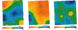
In our area, soils are highly variable. A 20 acre field could contain 4 or more different soil types – each providing unique challenges and growing conditions for the crop. If high soil variability is suspected in a field, County Farm Centre will recommend GPS soil sampling. This provides a detailed view of soil types and nutrients across the entire field.
Zone sampling and grid sampling are the 2 different methods of GPS sampling. The method used will depend on grower preference and the amount of historical data a grower has collected from their fields.
| Cookie | Duration | Description |
|---|---|---|
| cookielawinfo-checkbox-analytics | 11 months | This cookie is set by GDPR Cookie Consent plugin. The cookie is used to store the user consent for the cookies in the category "Analytics". |
| cookielawinfo-checkbox-functional | 11 months | The cookie is set by GDPR cookie consent to record the user consent for the cookies in the category "Functional". |
| cookielawinfo-checkbox-necessary | 11 months | This cookie is set by GDPR Cookie Consent plugin. The cookies is used to store the user consent for the cookies in the category "Necessary". |
| cookielawinfo-checkbox-others | 11 months | This cookie is set by GDPR Cookie Consent plugin. The cookie is used to store the user consent for the cookies in the category "Other. |
| cookielawinfo-checkbox-performance | 11 months | This cookie is set by GDPR Cookie Consent plugin. The cookie is used to store the user consent for the cookies in the category "Performance". |
| viewed_cookie_policy | 11 months | The cookie is set by the GDPR Cookie Consent plugin and is used to store whether or not user has consented to the use of cookies. It does not store any personal data. |